 Winter sucks in the Midwest, you don’t have to tell me – I know. Every section of the U.S. has its one bad season, it happens. The thing you need to do is relocate, temporarily. Well, as temporarily as you can afford but for the bouldering adventurer, 4-days are all you need.
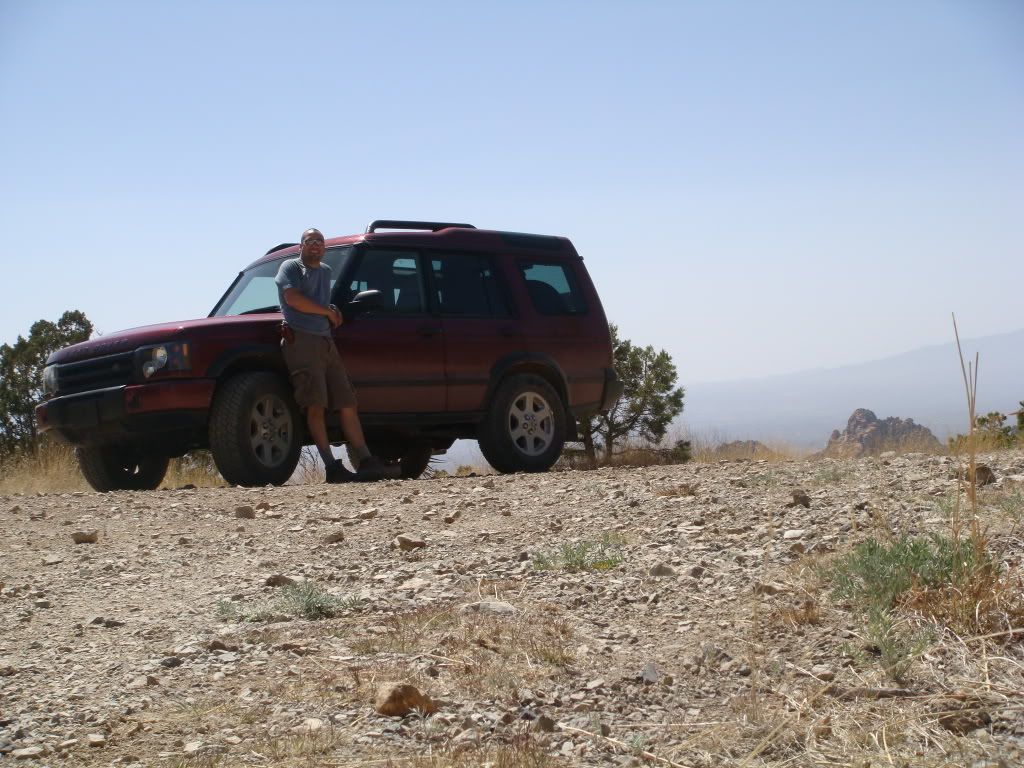
 Arizona is known for quite a few things, one of them is its fantastic winters. Even up though late spring the weather is mild during the day and at night will still require a sleeping bag or blanket for those who like to rough-it. I’d recommend something light, like a Northwestern Mountaineering. The reason I’m kicking you on this light-diet, is because where we are going, water is very difficult to find. Water is also very heavy. For 2-days in the high desert, bouldering, you will need 10L at least. That’s just over 2 gallons and if a gallon weighs roughly 9 pounds well, the math is on you.

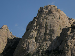
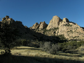
Another thing Arizona is known for is its abundance of bouldering, mountaineering, and rock-climbing spots. The place we are headed immersed in history. It sheltered the Chiricahua Apache during times of raids and war. Cochise, the great Chiricahua Apache chief rests here buried overlooking his mighty stronghold. The Cochise stronghold is picturesque rocky area located in the middle region of the Dragoon Mountains. The mighty peaks stand out in the skyline like giant rock tombstones. Seeing the way boulders here rest, will remind you of picking out shapes in the clouds. The Clanton gang held up in the northern part of these mountains hiding gold and plotting their next train robbery. There are old U.S. Army camps and mines scattered throughout this entire range. Not only home to legend but to some of the best bouldering and rock-climbing in the Southwest.
 The Sheep’s Head marks the southern point of the stronghold. Its crest starts at 5,800ft peaking out at just over 6,500ft. I set out for 2-days to summit the Sheep’s Head dome. Contemplating the weight of water is difficult until you are carrying it for a couple miles over very rough country. The elevation of where I was dropped was right at 5,200ft: which is numerals an all uphill journey. I was pleased to find a nice camp spot in some cedar trees right at the base of the dome.
 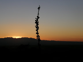 It was in the early afternoon when I finished setting up camp and I decided that I’d do some bouldering around the area to warm up for my dome summit the next morning. The bouldering here is magnificent and with the sunny high 70 degree weather it really makes you want to just pull up and move here. Climbing up the nearby peaks really gives you respect for the natives that used to call this place home. With the sun going down in an explosion of dark reds and orange I thought about the next day’s climb.
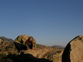
 With zero-hour upon me I ate a hearty breakfast. I knew I’d need the fuel if I was to find my way to the top carrying 3-liters of water, snacks, the camera, etc. I set out and passed some technical climbers that were prepping to go up the face. I approached the dome from the front and found a way up free-bouldering its right side. The climb to the Sheep’s Head summit took me roughly 3 hours. The view from the top was spectacular and so was the wind. The calm sunny day had become windy and overcast by the time I reached the top but the cooler weather was appreciated after the difficult climb.

Directions and whatnot
 Access is to the stronghold can only be accomplished in 4wd or on foot. As you see the sign marking the National Forrest, on your left is a cattle guard and a road heading toward the tall rocky peaks. There are a lot of unmarked dirt roads here as you go over the cattle guard try and keep right toward the Sheep’s Head.
Remember: Let not the present leave the trash for the future to clean from the past
If you'd like to see more pics, visit my web album at: http://picasaweb.google.com/LJoChavo
Special Thanks To: Jigga, for taking such spectacular pics and putting up with my fast pace. Donnie, no trip would be the same w/o u!

Well, I guess I’ve done better things with my time, but I this whole Skeleton Canyon thing was just stuck in my head. My mom had given me this book called “Lost Dutchman in Cochise County”, by Tim Johnson. Cochise is the county I live in now, before you ask. It’s in south eastern Arizona the epitome of BFE. And yes, that’s exactly what you think it means. So it’s practically my backyard that’s holding the events portrayed in this guy’s book. I guess I watched too much Indiana Jones when I was a kid. Oh, and yea I am going to see the new one as well. ..

So here is some brief history about how many of the old gangs formed up after the Civil War. The War had been going on since 1861 and then four years later Confederate soldiers who had fought and gave their lives were given nothing. Many of those who were landowners and fought for the Confederate Army where relieved of their land. They had nothing and they were pretty pissed off and rightly so after fighting and giving almost all to receive nothing. Many of these ex-soldiers fled west to New Mexico and Arizona. Mainly consisting of groups, the Confederate soldiers stuck together with those they had fought with and it made it easy to have enough buddies that had nothing to lose and everything to gain. So that’s it with the history lesson now back to the search.
Now Arizona is filled with legend and one of the most famous is 
of the Lost Dutchman. In Phoenix (west of the Superstition Mountains) are restaurants named after him and gift shops offering trinkets and crapperware a plenty. As I stated before, all legends contain some truth. The Dutchman tale is just what they call a “Chinese whisper” the tale having gained and lost details during the word-of-mouth passing along. However, there was some legitimate history about the Clanton gang holding up banks, robbing trains (8 to be exact), and stagecoaches here in the area surrounding Tombstone. The Clanton’s got new neighbors, the McLaury’s. Together the two families formed the Cowboy Gang made famous again in the film Tombstone (1993). I watched that movie a lot when I was a kid. You can see the OK corral and the graves of Wyatt Earp and company in Tombstone still to this day, but for a $20 ticket. However there is some factual history about gangs and mountain hideouts right here in Cochise County.
So, I read this book, like 4 times and researched on the net for clues and locations. It took me about 12hrs online and another 2 days of scouting around in the wrong places to realize more map research was necessary. It was time to come home, regroup, and check the maps again. Having already been out in the area the topo maps made much more sense and the second time when I returned I could see it in my head matching with the terrain. So I’m thinking there is a lot of stuff about a hideout in the Dragoon Mountains and lost treasure. Considering all the hoopla, the tale that is more factual is probably the one about the Clanton Gang leaving loot behind. Big brother Ike Clanton had caused a bunch of trouble and about the time Wyatt Earp and company was coming to light that ass up, they decided to flee. They got caught in their hideout, in this Skeleton Canyon, and had a big shootout. They took what they could of their stash and headed out on horseback in a hurry. When members were eventually caught they were relieved of their gold. And considering the amounts stolen from trains and stages it just didn’t add up. Did they leave the rest of it in Skeleton Canyon? Hell I’ll be happy if I can just find out the place even exists and so far not so good…..
 Now this Author Tim Johnson talks about some people that went looking for the Clanton Hideout this Skeleton Canyon have been shot at and chased off. Well, I’m not taking any chances, so I packed up my RAV-9mm carbine semi-automatic assault rifle and headed out – smiling. So here is the skinny on Skeleton Canyon, I found it.
The walk into the canyon is about 3 miles in. I could only get the Land Rover to the flat before the actual canyon started.  The steep and deep drop off made it apparent it was necessary to change to foot. So I strapped on my pack grabbed the gat and headed off into the unknown; remembering my topo maps visualizing my surroundings in 2d. The hike in was nice. The large boulders in the canyon floor made traveling interesting; that and the high possibility of snakes. It took me about an hour to reach the site. I stopped to take some photos of this strange fortified post I found. It was about 30 feet up on the left canyon wall. It reminded me of a machine gun nest. It was a perfect spot to fend off enemies coming in and you could tell by the large stacked rocks, someone put some sweat into it for some reason.

As I approached the canyon I got this eerie feeling like I was being watched. Maybe it was just the energy of this place.The first thing I noticed was the hideout shack that had collapsed. Walking up the bullet holes were obvious and in multitude. There was definitely a shoot out here at some point. Even the trees and the water trough had holes in them.

Looking at the water trough and the holes on one corner I pictured a man using it as cover and as he peers around the edge the shots come in numbers just missing him and causing the water to begin to drain. The little shack is not much more than a ruin but inside you can still see the fire pit and the hanger above it. Notice the nice shotgun blast to the front door......

 I didn’t find much, just more really old trees with little bullet holes in them. Who knows what’s here. I came light this time and wanted to just get a location. I wasn't real comfy leaving my LR parked 3miles back. I will return and do a better job of digging around – maybe with a metal detector. Regardless the legend of Skeleton Canyon is based on a real place and despite what lore will tell us, its obvious that there was a hideout of sorts here at one time. And also that shots have been fired. I found no signs of modern ammunition. And there were no spent casings lying about. They are buried in the sands of time - so to speak. Whatever happened here has caused stories and legends to emerge. I look forward to going back even if I don't find the missing loot. Happy Journeys!